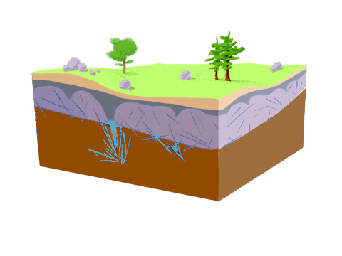
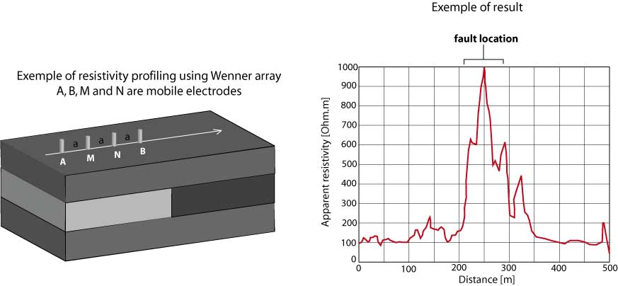
Locate fault or dyke
In weathered cristalline context, the general high clay content results in low permeability. In this case, the groundwater extraction can only be performed in the unweathered rock at larger depth. In order to be able to extract water, people have to find high permeability areas generally located in fault zones areas.
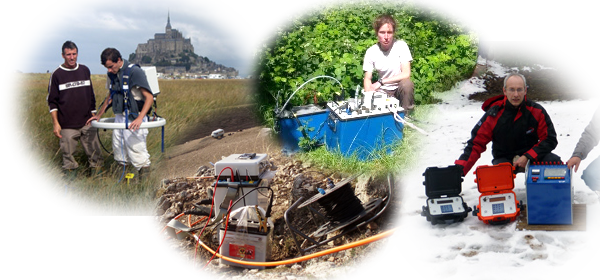
Different geophysical methods measuring the soil electrical resistivity can be used to detect these targets. The profiling simply consists in moving a ABMN quadripole of fixed dimension. The spacing between electrodes is adapted to the depth of the target. The Syscal instrument range is well adapted to locate shallow to deep fault or dyke (Syscal Junior / Syscal R1 / Syscal R2 / Syscal Pro). With its high power, the VIP range transmitter (up to 10 kW) associated to the Elrec or Fullwave range receivers can be used to increase the electrode spacing, to locate deeper targets.
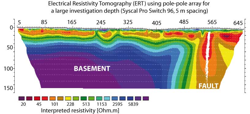
This methodology allows to highlight lateral resistivity variation along a profile, but not to locate the depth and vertical extension of the fault. Therefore it can be completed by an electrical resistivity tomography (ERT) on the location of the previous anomaly. The Syscal Switch range of equipment can also be used to perform shallow to deep electrical resistivity tomographies (Syscal Junior Switch / Syscal R1 Switch / Syscal Pro Switch). Our equipments allow to image length, depth and dip angle of the fault to identify the best drilling location.
The Promis 10 slingram type EM profiler or the T-VLF can also be useful to detect faults that are generally filled with clay (conductive) or not (resistive).
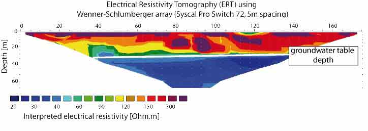
Water table detection
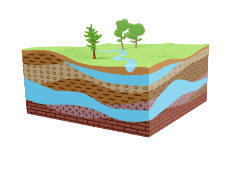
In sedimentary context, the groundwater is generally located in the pore space of permeable rock layers. Depending on the rock porosity, rock permeability and sometime fracture and karstic network, the number of ground water table, their thickness and their spatial heterogeneity may vary greatly. In order to locate the most favorable site to setup a drilling, several geophysical investigations can be performed.
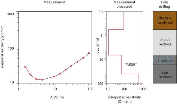
The first and simplest geophysical method is the electrical sounding. It is performed using four electrotes (a quadripole), centered on the investigation point. Several measurements are performed, each time increasing the electrode spacing. In that way, the investigation depth is increased at each measurement so that one can obtain after data inversion a log of resistivity. Although this methods is based on 1D assumption (no lateral variation of resistivity), it has been showed to be very powerfull for decades. It can be easily performed using the Syscal instrument range (Syscal Junior / Syscal R1 / Syscal R2 / Syscal Pro) or the VIP or TIPIX transmitters range associated to the Elrec range of receivers.
In cases where the geology is more complex (faults, inclusion, clay lenses, etc.), the groundwater level may vary laterally. Electrical Resistivity Tomography may therefore be a good tool to assess the best location of a drilling in this context. This method has been applied in a very large number of hydrological contexts and is often interpreted jointly with hydrological data (Koch et al., 2009). The Syscal Switch range of equipment are adapted for this type of application for shallow to deep aquifers (Syscal Junior Switch / Syscal R1 Switch / Syscal Pro Switch).
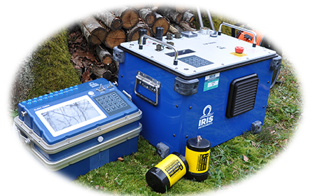
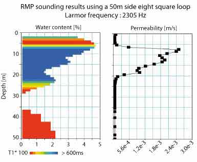
Finally, the most adapted method to locate and characterize groundwater table is the Nuclear Magnetic Resonance (NMR, Legchenko, 2013). This method consists in exiting the molecule of water in the soil and to measure their electromagnetic response. Contrary to the electrical resistivity, this measure is directly linked to the aquifere characteristics (water content, permeability). NMR is able to provide data on the water content and permeability of the soil, avoiding you to locate a drilling in a high water content but low permeable layer that would result in a low productivity. This instrument has been proven reliable in a large number of contexts (karsts, Vouillamoz et al., 2003; hard-rock aquifers, Legchenko et al., 2006, fractured aquifers, Wyns et al., 2004; coastal aquifers, Vouillamoz et al, 2007, water-filled cavities, Girard et al., 2005; glacier, Vincent et al., 2015, etc.). The Numis range equipment allows to realize NMR sounding up to 150m of depth.
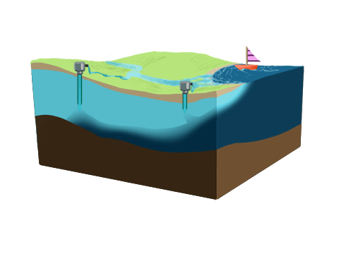
Salt water wedge
In coastal areas, the multiplication of groundwater pumping can sometime modify the natural salt water wedge and create salted water intrusion under land area. This intrusion may have a catastrophic impact on water resource, agriculture and industry (Werner et al., 2013).
To measure the extension of the salt water wedge in lands, electrical resistivity soundings, tomography or monitoring can be performed (Nowroozi et al., 1999, Rey et al., 2013, De Franco et al., 2009) with the Syscal and Syscal Switch range (Syscal Junior / Syscal Junior Switch / Syscal R1 / Syscal R1 Switch / Syscal R2 / Syscal Pro / Syscal Pro Switch).
.
The measurement of the soil electrical resistivity can also be performed using the Promis 10 Slingram type EM profiler that allows to measure the soil electrical resistivity with a high productivity.
References
De Franco, R., Biella, G., Tosi, L., Teatini, P., Lozej, A., Chiozzotto, B., ... & Bassan, V. (2009). Monitoring the saltwater intrusion by time lapse electrical resistivity tomography: The Chioggia test site (Venice Lagoon, Italy). Journal of Applied Geophysics, 69(3), 117-130.
Girard, J. F., Boucher, M., Legchenko, A., & Baltassat, J. M. (2005, September). Numerical modeling of magnetic resonance signal from water-filled cavities. In Near Surface 2005-11th European Meeting of Environmental and Engineering Geophysics.
Koch, K., Wenninger, J., Uhlenbrook, S., & Bonell, M. (2009). Joint interpretation of hydrological and geophysical data: electrical resistivity tomography results from a process hydrological research site in the Black Forest Mountains, Germany. Hydrological Processes, 23(10), 1501-1513.
Legchenko, A., Descloitres, M., Bost, A., Ruiz, L., Reddy, M., Girard, J. F., ... & Braun, J. J. (2006). Resolution of MRS Applied to the Characterization of Hard‐Rock Aquifers. Ground Water, 44(4), 547-554.
Legchenko, A. (2013). Magnetic resonance imaging for groundwater. John Wiley & Sons.
Nowroozi, A. A., Horrocks, S. B., & Henderson, P. (1999). Saltwater intrusion into the freshwater aquifer in the eastern shore of Virginia: a reconnaissance electrical resistivity survey. Journal of Applied Geophysics, 42(1), 1-22.
Rey, J., Martínez, J., Barberá, G. G., García-Aróstegui, J. L., García-Pintado, J., & Martínez-Vicente, D. (2013). Geophysical characterization of the complex dynamics of groundwater and seawater exchange in a highly stressed aquifer system linked to a coastal lagoon (SE Spain). Environmental earth sciences, 70(5), 2271-2282.
Vincent, C., Thibert, E., Gagliardini, O., Legchenko, A., Gilbert, A., Garambois, S., ... & Girard, J. F. (2015). Mechanisms of subglacial cavity filling in Glacier de Tête Rousse, French Alps. Journal of Glaciology, 61(228), 609-623.
Vouillamoz, J. M., Legchenko, A., Albouy, Y., Bakalowicz, M., Baltassat, J. M., & Al‐Fares, W. (2003). Localization of saturated karst aquifer with magnetic resonance sounding and resistivity imagery. Ground water, 41(5), 578-586.
Vouillamoz, J. M., Chatenoux, B., Mathieu, F., Baltassat, J. M., & Legchenko, A. (2005, September). Characterization of unconsolidated coastal aquifers with magnetic resonance and electrical soundings. In Near Surface 2005-11th European Meeting of Environmental and Engineering Geophysics.
Werner, A. D., Bakker, M., Post, V. E., Vandenbohede, A., Lu, C., Ataie-Ashtiani, B., ... & Barry, D. A. (2013). Seawater intrusion processes, investigation and management: recent advances and future challenges. Advances in Water Resources, 51, 3-26.
Wyns, R., Baltassat, J. M., Lachassagne, P., Legchenko, A., Vairon, J., & Mathieu, F. (2004). Application of proton magnetic resonance soundings to groundwater reserve mapping in weathered basement rocks (Brittany, France). Bulletin de la société géologique de France, 175(1), 21-34.